We and our partners use technologies, such as cookies, to recognize you and show you more of what you like. Please read our Privacy Policy to learn more. By using this website you agree to the use of those technologies.
I agree.
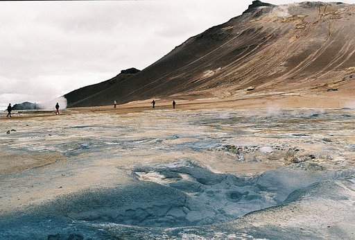
La région du lac Myvatn comprend plusieurs centres d'intérêt : La zone volcanique du Krafla, dernière zone d’activité autour du lac, le site de Dimmuborgir , spectaculaire champ de lave avec notamment les célèbres « châteaux de lave », et l’impressionnant site géothermique de Hverir , situé au Nord-Est du lac Mývatn et surplombé par le mont ocre Námafjall. Le H2S emplit l'air, on marche entre les solfatares, les marmites de boue, sur un sol ocre souffré. L'ascension du mont est rude dans ses premiers mètres et la respiration courte, mais la vue vaut la sueur dépensée. La descente côté sud est risquée, le chemin disparait au milieu des scories, on se prend à imiter le skieur pour rejoindre le bas. A éviter par temps de pluie. (google traduction) The Myvatn Lake area includes several points of interest: the Krafla Volcanic Zone, the last activity zone around the lake, the Dimmuborgir site, a spectacular lava field with the famous "lava castles", and the impressive Hverir geothermal site, located north-east of Lake Mývatn and overlooked by the Námafjall ocher mountain. The H2S fills the air, one walks between the solfatares, the pots of mud, on a soil ocher suffers. The ascent of the mountain is rough in its first meters and the breathing short, but the view is worth the sweat spent. The descent south side is risky, the path disappears in the middle of slag, one starts to imitate the skier to reach the bottom. To avoid in rainy weather.
La région du lac Myvatn comprend plusieurs centres d'intérêt : La zone volcanique du Krafla, dernière zone d’activité autour du lac, le site de Dimmuborgir , spectaculaire champ de lave avec notamment les célèbres « châteaux de lave », et l’impressionnant site géothermique de Hverir , situé au Nord-Est du lac Mývatn et surplombé par le mont ocre Námafjall. Le H2S emplit l'air, on marche entre les solfatares, les marmites de boue, sur un sol ocre souffré. L'ascension du mont est rude dans ses premiers mètres et la respiration courte, mais la vue vaut la sueur dépensée. La descente côté sud est risquée, le chemin disparait au milieu des scories, on se prend à imiter le skieur pour rejoindre le bas. A éviter par temps de pluie. (google traduction) The Myvatn Lake area includes several points of interest: the Krafla Volcanic Zone, the last activity zone around the lake, the Dimmuborgir site, a spectacular lava field with the famous "lava castles", and the impressive Hverir geothermal site, located north-east of Lake Mývatn and overlooked by the Námafjall ocher mountain. The H2S fills the air, one walks between the solfatares, the pots of mud, on a soil ocher suffers. The ascent of the mountain is rough in its first meters and the breathing short, but the view is worth the sweat spent. The descent south side is risky, the path disappears in the middle of slag, one starts to imitate the skier to reach the bottom. To avoid in rainy weather.
La région du lac Myvatn comprend plusieurs centres d'intérêt : La zone volcanique du Krafla, dernière zone d’activité autour du lac, le site de Dimmuborgir , spectaculaire champ de lave avec notamment les célèbres « châteaux de lave », et l’impressionnant site géothermique de Hverir , situé au Nord-Est du lac Mývatn et surplombé par le mont ocre Námafjall. Le H2S emplit l'air, on marche entre les solfatares, les marmites de boue, sur un sol ocre souffré. L'ascension du mont est rude dans ses premiers mètres et la respiration courte, mais la vue vaut la sueur dépensée. La descente côté sud est risquée, le chemin disparait au milieu des scories, on se prend à imiter le skieur pour rejoindre le bas. A éviter par temps de pluie. (google traduction) The Myvatn Lake area includes several points of interest: the Krafla Volcanic Zone, the last activity zone around the lake, the Dimmuborgir site, a spectacular lava field with the famous "lava castles", and the impressive Hverir geothermal site, located north-east of Lake Mývatn and overlooked by the Námafjall ocher mountain. The H2S fills the air, one walks between the solfatares, the pots of mud, on a soil ocher suffers. The ascent of the mountain is rough in its first meters and the breathing short, but the view is worth the sweat spent. The descent south side is risky, the path disappears in the middle of slag, one starts to imitate the skier to reach the bottom. To avoid in rainy weather.
La région du lac Myvatn comprend plusieurs centres d'intérêt : La zone volcanique du Krafla, dernière zone d’activité autour du lac, le site de Dimmuborgir , spectaculaire champ de lave avec notamment les célèbres « châteaux de lave », et l’impressionnant site géothermique de Hverir , situé au Nord-Est du lac Mývatn et surplombé par le mont ocre Námafjall. Le H2S emplit l'air, on marche entre les solfatares, les marmites de boue, sur un sol ocre souffré. L'ascension du mont est rude dans ses premiers mètres et la respiration courte, mais la vue vaut la sueur dépensée. La descente côté sud est risquée, le chemin disparait au milieu des scories, on se prend à imiter le skieur pour rejoindre le bas. A éviter par temps de pluie. (google traduction) The Myvatn Lake area includes several points of interest: the Krafla Volcanic Zone, the last activity zone around the lake, the Dimmuborgir site, a spectacular lava field with the famous "lava castles", and the impressive Hverir geothermal site, located north-east of Lake Mývatn and overlooked by the Námafjall ocher mountain. The H2S fills the air, one walks between the solfatares, the pots of mud, on a soil ocher suffers. The ascent of the mountain is rough in its first meters and the breathing short, but the view is worth the sweat spent. The descent south side is risky, the path disappears in the middle of slag, one starts to imitate the skier to reach the bottom. To avoid in rainy weather.
La région du lac Myvatn comprend plusieurs centres d'intérêt : La zone volcanique du Krafla, dernière zone d’activité autour du lac, le site de Dimmuborgir , spectaculaire champ de lave avec notamment les célèbres « châteaux de lave », et l’impressionnant site géothermique de Hverir , situé au Nord-Est du lac Mývatn et surplombé par le mont ocre Námafjall. Le H2S emplit l'air, on marche entre les solfatares, les marmites de boue, sur un sol ocre souffré. L'ascension du mont est rude dans ses premiers mètres et la respiration courte, mais la vue vaut la sueur dépensée. La descente côté sud est risquée, le chemin disparait au milieu des scories, on se prend à imiter le skieur pour rejoindre le bas. A éviter par temps de pluie. (google traduction) The Myvatn Lake area includes several points of interest: the Krafla Volcanic Zone, the last activity zone around the lake, the Dimmuborgir site, a spectacular lava field with the famous "lava castles", and the impressive Hverir geothermal site, located north-east of Lake Mývatn and overlooked by the Námafjall ocher mountain. The H2S fills the air, one walks between the solfatares, the pots of mud, on a soil ocher suffers. The ascent of the mountain is rough in its first meters and the breathing short, but the view is worth the sweat spent. The descent south side is risky, the path disappears in the middle of slag, one starts to imitate the skier to reach the bottom. To avoid in rainy weather.
La région du lac Myvatn comprend plusieurs centres d'intérêt : La zone volcanique du Krafla, dernière zone d’activité autour du lac, le site de Dimmuborgir , spectaculaire champ de lave avec notamment les célèbres « châteaux de lave », et l’impressionnant site géothermique de Hverir , situé au Nord-Est du lac Mývatn et surplombé par le mont ocre Námafjall. Le H2S emplit l'air, on marche entre les solfatares, les marmites de boue, sur un sol ocre souffré. L'ascension du mont est rude dans ses premiers mètres et la respiration courte, mais la vue vaut la sueur dépensée. La descente côté sud est risquée, le chemin disparait au milieu des scories, on se prend à imiter le skieur pour rejoindre le bas. A éviter par temps de pluie. (google traduction) The Myvatn Lake area includes several points of interest: the Krafla Volcanic Zone, the last activity zone around the lake, the Dimmuborgir site, a spectacular lava field with the famous "lava castles", and the impressive Hverir geothermal site, located north-east of Lake Mývatn and overlooked by the Námafjall ocher mountain. The H2S fills the air, one walks between the solfatares, the pots of mud, on a soil ocher suffers. The ascent of the mountain is rough in its first meters and the breathing short, but the view is worth the sweat spent. The descent south side is risky, the path disappears in the middle of slag, one starts to imitate the skier to reach the bottom. To avoid in rainy weather.
La région du lac Myvatn comprend plusieurs centres d'intérêt : La zone volcanique du Krafla, dernière zone d’activité autour du lac, le site de Dimmuborgir , spectaculaire champ de lave avec notamment les célèbres « châteaux de lave », et l’impressionnant site géothermique de Hverir , situé au Nord-Est du lac Mývatn et surplombé par le mont ocre Námafjall. Le H2S emplit l'air, on marche entre les solfatares, les marmites de boue, sur un sol ocre souffré. L'ascension du mont est rude dans ses premiers mètres et la respiration courte, mais la vue vaut la sueur dépensée. La descente côté sud est risquée, le chemin disparait au milieu des scories, on se prend à imiter le skieur pour rejoindre le bas. A éviter par temps de pluie. (google traduction) The Myvatn Lake area includes several points of interest: the Krafla Volcanic Zone, the last activity zone around the lake, the Dimmuborgir site, a spectacular lava field with the famous "lava castles", and the impressive Hverir geothermal site, located north-east of Lake Mývatn and overlooked by the Námafjall ocher mountain. The H2S fills the air, one walks between the solfatares, the pots of mud, on a soil ocher suffers. The ascent of the mountain is rough in its first meters and the breathing short, but the view is worth the sweat spent. The descent south side is risky, the path disappears in the middle of slag, one starts to imitate the skier to reach the bottom. To avoid in rainy weather.
La région du lac Myvatn comprend plusieurs centres d'intérêt : La zone volcanique du Krafla, dernière zone d’activité autour du lac, le site de Dimmuborgir , spectaculaire champ de lave avec notamment les célèbres « châteaux de lave », et l’impressionnant site géothermique de Hverir , situé au Nord-Est du lac Mývatn et surplombé par le mont ocre Námafjall. Le H2S emplit l'air, on marche entre les solfatares, les marmites de boue, sur un sol ocre souffré. L'ascension du mont est rude dans ses premiers mètres et la respiration courte, mais la vue vaut la sueur dépensée. La descente côté sud est risquée, le chemin disparait au milieu des scories, on se prend à imiter le skieur pour rejoindre le bas. A éviter par temps de pluie. (google traduction) The Myvatn Lake area includes several points of interest: the Krafla Volcanic Zone, the last activity zone around the lake, the Dimmuborgir site, a spectacular lava field with the famous "lava castles", and the impressive Hverir geothermal site, located north-east of Lake Mývatn and overlooked by the Námafjall ocher mountain. The H2S fills the air, one walks between the solfatares, the pots of mud, on a soil ocher suffers. The ascent of the mountain is rough in its first meters and the breathing short, but the view is worth the sweat spent. The descent south side is risky, the path disappears in the middle of slag, one starts to imitate the skier to reach the bottom. To avoid in rainy weather.
At the extreme north-west point of Crete, at the end of the Gramvousa peninsula you can admire a stunning place called Balos Lagoon. You first need to drive an 8km dirt track at a very low speed (30mn for 8km!) before parking your car. Take your backpack and photographic gear and take the path in the mountains: suddenly, the view opens in front of you and there's this amazing view before your eyes! Usually very crowded in full summer (tourists reach the place by sea as it's in all touristic cruises program), I was very lucky to go there during a cloudy day and almost nobody on the beach. So I could walk all over the place, in every direction and finally spent over 5 hours there.... And it was the perfect time to shoot some long exposure tripod shots with a very slow b&w film like the Adox CMS20 exposed at 12 iso and exposed for a few seconds at f/22 for maximal sharpness and fine grain photos. (Home processed in Adox Adotech II for 8.5 mn at 20°)
At the extreme north-west point of Crete, at the end of the Gramvousa peninsula you can admire a stunning place called Balos Lagoon. You first need to drive an 8km dirt track at a very low speed (30mn for 8km!) before parking your car. Take your backpack and photographic gear and take the path in the mountains: suddenly, the view opens in front of you and there's this amazing view before your eyes! Usually very crowded in full summer (tourists reach the place by sea as it's in all touristic cruises program), I was very lucky to go there during a cloudy day and almost nobody on the beach. So I could walk all over the place, in every direction and finally spent over 5 hours there.... And it was the perfect time to shoot some long exposure tripod shots with a very slow b&w film like the Adox CMS20 exposed at 12 iso and exposed for a few seconds at f/22 for maximal sharpness and fine grain photos. (Home processed in Adox Adotech II for 8.5 mn at 20°)
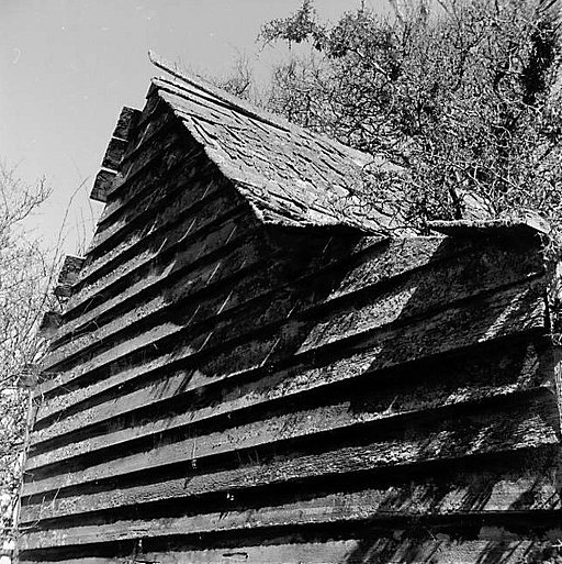
The 70 Mile Bush covered a large area of Lower North Island. It was settled by an Assisted migration scheme for Scandinavian settlers who found their land purchase did not match up with the description. There was no going back. With axe and saw they felled native bush and turned it into farmland. It was a very hard life. I am lucky to have found this cottage with barn which offers a glimpse of a settler's life in the 1870's in Wairarapa.
The 70 Mile Bush covered a large area of Lower North Island. It was settled by an Assisted migration scheme for Scandinavian settlers who found their land purchase did not match up with the description. There was no going back. With axe and saw they felled native bush and turned it into farmland. It was a very hard life. I am lucky to have found this cottage with barn which offers a glimpse of a settler's life in the 1870's in Wairarapa.
At the extreme north-west point of Crete, at the end of the Gramvousa peninsula you can admire a stunning place called Balos Lagoon. You first need to drive an 8km dirt track at a very low speed (30mn for 8km!) before parking your car. Take your backpack and photographic gear and take the path in the mountains: suddenly, the view opens in front of you and there's this amazing view before your eyes! Usually very crowded in full summer (tourists reach the place by sea as it's in all touristic cruises program), I was very lucky to go there during a cloudy day and almost nobody on the beach. So I could walk all over the place, in every direction and finally spent over 5 hours there.... And it was the perfect time to shoot some long exposure tripod shots with a very slow b&w film like the Adox CMS20 exposed at 12 iso and exposed for a few seconds at f/22 for maximal sharpness and fine grain photos. (Home processed in Adox Adotech II for 8.5 mn at 20°)
At the extreme north-west point of Crete, at the end of the Gramvousa peninsula you can admire a stunning place called Balos Lagoon. You first need to drive an 8km dirt track at a very low speed (30mn for 8km!) before parking your car. Take your backpack and photographic gear and take the path in the mountains: suddenly, the view opens in front of you and there's this amazing view before your eyes! Usually very crowded in full summer (tourists reach the place by sea as it's in all touristic cruises program), I was very lucky to go there during a cloudy day and almost nobody on the beach. So I could walk all over the place, in every direction and finally spent over 5 hours there.... And it was the perfect time to shoot some long exposure tripod shots with a very slow b&w film like the Adox CMS20 exposed at 12 iso and exposed for a few seconds at f/22 for maximal sharpness and fine grain photos. (Home processed in Adox Adotech II for 8.5 mn at 20°)
At the extreme north-west point of Crete, at the end of the Gramvousa peninsula you can admire a stunning place called Balos Lagoon. You first need to drive an 8km dirt track at a very low speed (30mn for 8km!) before parking your car. Take your backpack and photographic gear and take the path in the mountains: suddenly, the view opens in front of you and there's this amazing view before your eyes! Usually very crowded in full summer (tourists reach the place by sea as it's in all touristic cruises program), I was very lucky to go there during a cloudy day and almost nobody on the beach. So I could walk all over the place, in every direction and finally spent over 5 hours there.... And it was the perfect time to shoot some long exposure tripod shots with a very slow b&w film like the Adox CMS20 exposed at 12 iso and exposed for a few seconds at f/22 for maximal sharpness and fine grain photos. (Home processed in Adox Adotech II for 8.5 mn at 20°)
At the extreme north-west point of Crete, at the end of the Gramvousa peninsula you can admire a stunning place called Balos Lagoon. You first need to drive an 8km dirt track at a very low speed (30mn for 8km!) before parking your car. Take your backpack and photographic gear and take the path in the mountains: suddenly, the view opens in front of you and there's this amazing view before your eyes! Usually very crowded in full summer (tourists reach the place by sea as it's in all touristic cruises program), I was very lucky to go there during a cloudy day and almost nobody on the beach. So I could walk all over the place, in every direction and finally spent over 5 hours there.... And it was the perfect time to shoot some long exposure tripod shots with a very slow b&w film like the Adox CMS20 exposed at 12 iso and exposed for a few seconds at f/22 for maximal sharpness and fine grain photos. (Home processed in Adox Adotech II for 8.5 mn at 20°)